Montenegro
 The
terrain of Montenegro ranges from high mountains along its borders with
Kosovo and Albania, through a segment of the Karst of the western Balkan
Peninsula, to a narrow coastal plain that is only one to four miles wide.
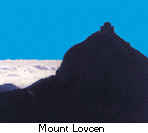
The coastal plain disappears completely in the north, where Mount Lovcen
and other ranges plunge abruptly into the inlet of the Gulf of Kotor. The
coastal region is noted for active seismicity.
The
terrain of Montenegro ranges from high mountains along its borders with
Kosovo and Albania, through a segment of the Karst of the western Balkan
Peninsula, to a narrow coastal plain that is only one to four miles wide.
The coastal plain disappears completely in the north, where Mount Lovcen
and other ranges plunge abruptly into the inlet of the Gulf of Kotor. The
coastal region is noted for active seismicity.
Montenegro's section of the Karst lies generally at elevations of
3,000 feet above sea level-although some areas rise to 6,000 feet. The
lowest segment is in the valley of the Zeta River, which flows at an elevation
of 1,500 feet. The river occupies the centre of Niksic Polje, a flat-floored, elongated
depression typical of karstic regions. The underlying rock is predominantly
limestone, which dissolves to form sinkholes and underground caves.
The river occupies the centre of Niksic Polje, a flat-floored, elongated
depression typical of karstic regions. The underlying rock is predominantly
limestone, which dissolves to form sinkholes and underground caves.
The high mountains of Montenegro include some of the most rugged terrain in Europe. They average more than 7,000 feet in elevation. Among notable peaks is Bobotov Peak in the Durmitor Mountains, which reaches 8,277 feet. The Montenegrin mountains were the most ice-eroded section of the Balkan Peninsula during the last glacial period.
